ルソン地震 (1645年)
1645年11月30日20時頃にフィリピン北部のルソン島を襲った地震
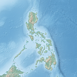
1645年ルソン地震(英語: 1645 Luzon earthquake)は、1645年11月30日夜8時ごろフィリピン北部のルソン島を襲った地震。ルソン島中部を通るサン・マヌエル断層とヌエヴァ・エシハ州のガバルドン断層を震源とするこの地震はMs7.5に上った[1]。
| 1645年ルソン地震 | |
|---|---|
|
地震の震央 | |
| 本震 | |
| 発生日 | 1645年11月30日 |
| 発生時刻 | 夜8時 |
| 震央 | フィリピン ルソン島 |
| 規模 | M7.5Ms |
| 被害 | |
| 死傷者数 | 不明、ただし多数 |
| 被害地域 | フィリピン・中部ルソン地方 |
|
| |
| プロジェクト:地球科学 プロジェクト:災害 | |
余震はその後数日間続き、1645年12月4日夜11時ごろ、本震と同じかより強い地震がおこり、さらなる被害を引き起こした[2]:226。
規模
編集地震で最も被害が大きい地域は南北で少なくとも490kmに上り、島の南部のバタンガス州とケソン州から東北のカガヤン州まで被害甚大であった。一方島の西部は(年代記で記述されない程度に)被害が少なかった。同時代の年代記ではマニラとその南、東、北における被害を記述しており、また中央山岳地帯、そして北部のカガヤン・バレー地方における大規模な地すべりと大きな地割れについての記述も多かった[3][4]。
マニラ
編集マニラでは市の守護聖人である聖アンデレの記念日を祝っている最中に地震がおこった。地震の被害は甚大で、マニラ市のほとんどが廃墟と化した[4]。マニラ大聖堂など多くの教会、建物、家屋が倒壊した[5][6]。およそ600人のスペイン人が死亡し、3000人のスペイン人が負傷した。同市を統治していた政府はスペイン人の被害のみ統計し、それ以外の人的被害は無視した[7][8]。
関連項目
編集脚注
編集- ^ Tsutsumi, H., Daligdig, J.A., Goto, H., Tungol, N.M., Kondo, H., Nakata, T., Okuno, M., and Sugito, N. (2006). Timing of surface-rupturing earthquakes on the Philippine fault zone in central Luzon Island, Philippines. EOS Transactions, American Geophysical Union 87, Supplement.
- ^ Blair, Emma Helen; Robertson, James Alexander, eds (1906). The Philippine Islands, 1493–1898. Volume 35 of 55 (1640-1649). Historical introduction and additional notes by Edward Gaylord Bourne;. Cleveland, Ohio: Arthur H. Clark Company. ISBN 9781153857611. OCLC 769945725
- ^ Maso, Saderra M (1913). ("Bulletin of the Seismological Society of America, Vols. 3 & 4 - Seismic Disturbances in Manila". Seismological Society of America.
- ^ a b Maso, Saderra M. (1904). "Volcano and Seismic Centers of the Philippine Archipelago". pp.73-75. Department of Commerce and Labor.
- ^ "The Third Cathedral". Manila Metropolitan Cathedral-Basilica Philippines. Retrieved on 2011-10-14.
- ^ Kneeland, Samuel (1888). "Volcano and Earthquakes". D. Lothrop Company, Boston.
- ^ Bautista, Maria Leonila; Bartolome Bautista (April–June 2004). “The Philippine historical earthquake catalog: its development, current state and future directions”. Annals of Geophysics 47 (2 & 3) 12 October 2010閲覧。.
- ^ Wong, Ivan. “Evaluating Seismic Hazards in Metro Manila, Philippines”. Timothy Dawson, Mark Dober. Oakland: URS Corp.. 12 October 2010閲覧。
