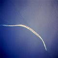
ファイル:Sable island.jpg

このプレビューのサイズ: 598 × 600 ピクセル。 その他の解像度: 239 × 240 ピクセル | 637 × 639 ピクセル。
元のファイル (637 × 639 ピクセル、ファイルサイズ: 103キロバイト、MIME タイプ: image/jpeg)
ファイルの履歴
過去の版のファイルを表示するには、その版の日時をクリックしてください。
| 日付と時刻 | サムネイル | 寸法 | 利用者 | コメント | |
|---|---|---|---|---|---|
| 現在の版 | 2005年12月2日 (金) 17:44 |  | 637 × 639 (103キロバイト) | Islandspec~commonswiki | Satellite image of Sable Island (Canada). Source:English Wikipedia. |
ファイルの使用状況
以下のページがこのファイルを使用しています:
グローバルなファイル使用状況
以下に挙げる他のウィキがこの画像を使っています:
- ar.wiki.x.io での使用状況
- arz.wiki.x.io での使用状況
- bg.wiki.x.io での使用状況
- ceb.wiki.x.io での使用状況
- da.wiki.x.io での使用状況
- de.wiki.x.io での使用状況
- de.wikivoyage.org での使用状況
- el.wiki.x.io での使用状況
- en.wiki.x.io での使用状況
- en.wikivoyage.org での使用状況
- eo.wiki.x.io での使用状況
- es.wiki.x.io での使用状況
- fi.wiki.x.io での使用状況
- fr.wikivoyage.org での使用状況
- fy.wiki.x.io での使用状況
- he.wiki.x.io での使用状況
- is.wiki.x.io での使用状況
- it.wiki.x.io での使用状況
- ko.wiki.x.io での使用状況
- nl.wiki.x.io での使用状況
- nn.wiki.x.io での使用状況
- no.wiki.x.io での使用状況
- pt.wiki.x.io での使用状況
- ru.wiki.x.io での使用状況
- sv.wiki.x.io での使用状況
- uk.wiki.x.io での使用状況
- ur.wiki.x.io での使用状況
- www.wikidata.org での使用状況
- zh.wiki.x.io での使用状況

