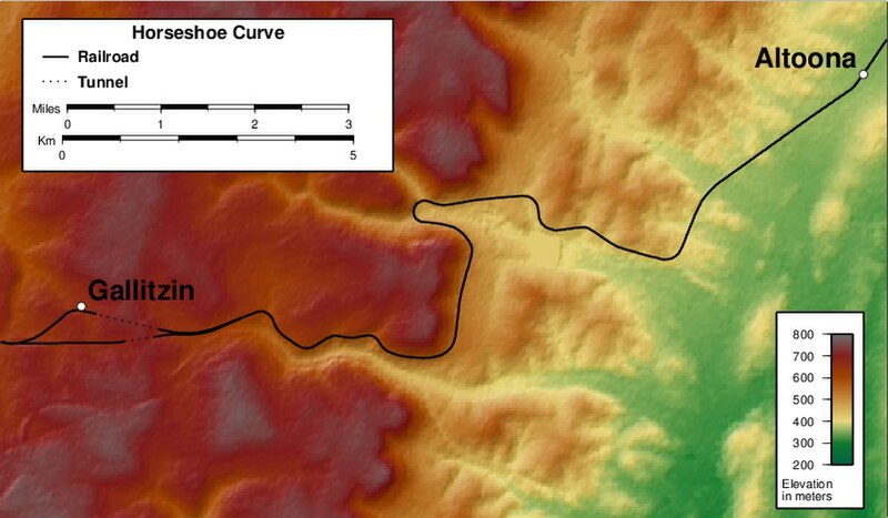
ファイル:Horseshoe Curve map.jpg

このプレビューのサイズ: 800 × 467 ピクセル。 その他の解像度: 320 × 187 ピクセル | 802 × 468 ピクセル。
元のファイル (802 × 468 ピクセル、ファイルサイズ: 81キロバイト、MIME タイプ: image/jpeg)
ファイルの履歴
過去の版のファイルを表示するには、その版の日時をクリックしてください。
| 日付と時刻 | サムネイル | 寸法 | 利用者 | コメント | |
|---|---|---|---|---|---|
| 現在の版 | 2012年3月20日 (火) 23:00 |  | 802 × 468 (81キロバイト) | Keithpickering~commonswiki | 1. Added colorbar for vertical scale. 2. Changed palette to add definiton to higher elevations. 3. Combined scale and legend; moved scales closer together. |
| 2012年3月3日 (土) 20:15 |  | 818 × 483 (84キロバイト) | Keithpickering~commonswiki | Increase font size of towns, to make legible in thumb. | |
| 2012年3月1日 (木) 20:04 |  | 818 × 483 (83キロバイト) | Keithpickering~commonswiki | Improved town dots | |
| 2012年3月1日 (木) 19:11 |  | 818 × 483 (83キロバイト) | Keithpickering~commonswiki | Fixed legend text | |
| 2012年3月1日 (木) 19:07 |  | 818 × 483 (83キロバイト) | Keithpickering~commonswiki |
ファイルの使用状況
以下のページがこのファイルを使用しています:
グローバルなファイル使用状況
以下に挙げる他のウィキがこの画像を使っています:
- ar.wiki.x.io での使用状況
- en.wiki.x.io での使用状況
- zh.wiki.x.io での使用状況