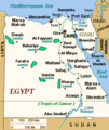
ファイル:Egypt-region-map-cities.gif
Egypt-region-map-cities.gif (314 × 374 ピクセル、ファイルサイズ: 17キロバイト、MIME タイプ: image/gif)
ファイルの履歴
過去の版のファイルを表示するには、その版の日時をクリックしてください。
| 日付と時刻 | サムネイル | 寸法 | 利用者 | コメント | |
|---|---|---|---|---|---|
| 現在の版 | 2013年11月28日 (木) 23:07 |  | 314 × 374 (17キロバイト) | Amrtarek | (Halaib Triangle) |
| 2013年5月2日 (木) 00:33 |  | 314 × 374 (18キロバイト) | Ras67 | cropped | |
| 2007年1月19日 (金) 09:56 |  | 315 × 377 (18キロバイト) | Yoruno | {{Information |Description=see http://en.wiki.x.io/wiki/Image:Egypt-region-map-cities.gif |Source=http://en.wiki.x.io/wiki/Image:Egypt-region-map-cities.gif |Date= |Author=see http://en.wiki.x.io/wiki/Image:Egypt-region-map-cities.gif |Permiss |
ファイルの使用状況
以下の 2 ページがこのファイルを使用しています:
グローバルなファイル使用状況
以下に挙げる他のウィキがこの画像を使っています:
- arz.wiki.x.io での使用状況
- ast.wiki.x.io での使用状況
- azb.wiki.x.io での使用状況
- bn.wiki.x.io での使用状況
- bs.wiki.x.io での使用状況
- ca.wiki.x.io での使用状況
- co.wiki.x.io での使用状況
- cs.wiki.x.io での使用状況
- da.wiki.x.io での使用状況
- en.wiki.x.io での使用状況
- en.wikivoyage.org での使用状況
- es.wiki.x.io での使用状況
- fiu-vro.wiki.x.io での使用状況
- fi.wikinews.org での使用状況
- fr.wiki.x.io での使用状況
- fy.wiki.x.io での使用状況
- gd.wiki.x.io での使用状況
- gl.wiki.x.io での使用状況
- he.wiki.x.io での使用状況
- hr.wiki.x.io での使用状況
- it.wiki.x.io での使用状況
- jv.wiki.x.io での使用状況
- mk.wiki.x.io での使用状況
- ml.wiki.x.io での使用状況
- ms.wiki.x.io での使用状況
- no.wiki.x.io での使用状況
このファイルのグローバル使用状況を表示する。


