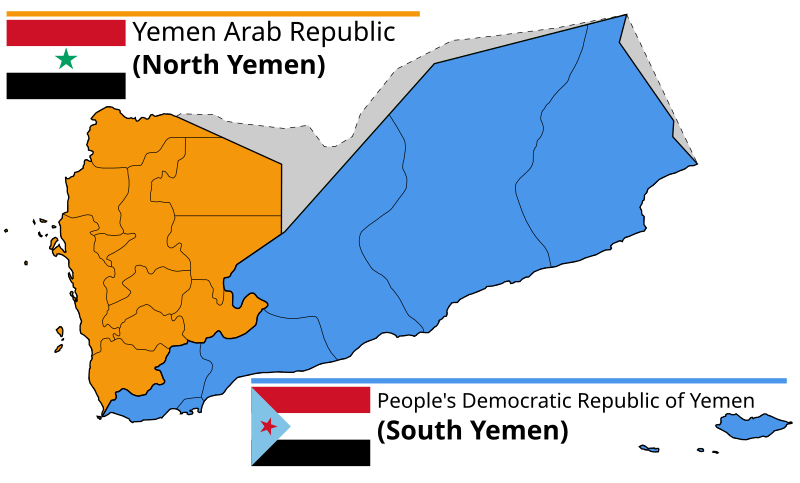
ファイル:Divided Yemen.svg

この SVG ファイルのこの PNG プレビューのサイズ: 800 × 483 ピクセル. その他の解像度: 320 × 193 ピクセル | 640 × 386 ピクセル | 1,024 × 618 ピクセル | 1,280 × 772 ピクセル | 2,560 × 1,544 ピクセル | 1,210 × 730 ピクセル。
元のファイル (SVG ファイル、1,210 × 730 ピクセル、ファイルサイズ: 72キロバイト)
ファイルの履歴
過去の版のファイルを表示するには、その版の日時をクリックしてください。
| 日付と時刻 | サムネイル | 寸法 | 利用者 | コメント | |
|---|---|---|---|---|---|
| 現在の版 | 2024年9月19日 (木) 11:08 |  | 1,210 × 730 (72キロバイト) | Abo Yemen | File uploaded using svgtranslate tool (https://svgtranslate.toolforge.org/). Added translation for ar. |
| 2023年12月20日 (水) 14:58 |  | 1,210 × 730 (71キロバイト) | אורי9 | File uploaded using svgtranslate tool (https://svgtranslate.toolforge.org/). Added translation for he. | |
| 2020年11月8日 (日) 19:47 |  | 1,210 × 730 (71キロバイト) | Panam2014 | Reverted to version as of 18:27, 8 July 2019 (UTC) | |
| 2020年8月9日 (日) 08:46 |  | 1,210 × 730 (44キロバイト) | AlMahra67 | text | |
| 2020年8月3日 (月) 18:05 |  | 1,210 × 730 (39キロバイト) | AlMahra67 | Changed dimensions | |
| 2020年8月3日 (月) 17:50 |  | 512 × 309 (39キロバイト) | AlMahra67 | If this map is supposed to show South and North Yemen division currently then it should be like this. The current divisions are based on the former divisions between the North and South Yemen. The previous version showed the new administrative boundaries that were created after unity. The new administrative boundary split areas that were part of the south. For example Dhale and Mukayras are shown as part of the North when they are in fact Southern. | |
| 2019年8月11日 (日) 23:07 |  | 1,210 × 730 (47キロバイト) | SharabSalam | Reverted to version as of 19:35, 20 October 2012 (UTC) none of these sources support this map. This map suppose to show South and North Yemen division currently.. Also Asir, Jazan and Najran should be part of North Yemen if it's a historical map. | |
| 2019年7月8日 (月) 18:27 |  | 1,210 × 730 (71キロバイト) | Flappiefh | This map is supposed to show these two former countries before their union (before 1990). It now shows the right governorates. Source 1 : https://legacy.lib.utexas.edu/maps/atlas_middle_east/yemen_divisions.jpg Source 2 : http://users.ox.ac.uk/~metheses/Ismail%20Thesis.pdf | |
| 2018年9月23日 (日) 11:57 |  | 1,210 × 730 (68キロバイト) | Nicolay Sidorov | ... | |
| 2018年9月23日 (日) 11:52 |  | 1,210 × 730 (65キロバイト) | Nicolay Sidorov | true border |
ファイルの使用状況
以下の 1 ファイルが、このファイルと重複しています (詳細):
- ファイル:Divided Yemen ar.svg ウィキメディア・コモンズ より
グローバルなファイル使用状況
以下に挙げる他のウィキがこの画像を使っています:
- af.wiki.x.io での使用状況
- ar.wiki.x.io での使用状況
- bn.wiki.x.io での使用状況
- ca.wiki.x.io での使用状況
- cs.wiki.x.io での使用状況
- en.wiki.x.io での使用状況
- es.wiki.x.io での使用状況
- eu.wiki.x.io での使用状況
- fa.wiki.x.io での使用状況
- fi.wiki.x.io での使用状況
- fr.wiki.x.io での使用状況
- gl.wiki.x.io での使用状況
- he.wiki.x.io での使用状況
- פורטל:גאוגרפיה/הידעת?/קטעי הידעת
- פורטל:המזרח התיכון/הידעת?/קטעי הידעת?
- ויקיפדיה:הידעת?/ממרץ 2016
- איחוד תימן
- ויקיפדיה:הידעת?/2017/ינואר
- תבנית:הידעת? 071
- תבנית:הידעת? 30 בינואר 2017
- ויקיפדיה:הידעת?/2021/אוקטובר
- תבנית:הידעת? 20 באוקטובר 2021
- פורטל:גאוגרפיה/הידעת?/34
- פורטל:המזרח התיכון/הידעת?/63
- התנועה הדרומית
- hr.wiki.x.io での使用状況
- hu.wiki.x.io での使用状況
- hy.wiki.x.io での使用状況
- id.wiki.x.io での使用状況
- it.wiki.x.io での使用状況
- ka.wiki.x.io での使用状況
- ms.wiki.x.io での使用状況
- nl.wiki.x.io での使用状況
- nn.wiki.x.io での使用状況
- or.wiki.x.io での使用状況
- sr.wiki.x.io での使用状況
このファイルのグローバル使用状況を表示する。


