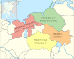
ファイル:Bishopric of Schwerin locator map (1250).svg

この SVG ファイルのこの PNG プレビューのサイズ: 761 × 600 ピクセル. その他の解像度: 305 × 240 ピクセル | 609 × 480 ピクセル | 975 × 768 ピクセル | 1,280 × 1,008 ピクセル | 2,560 × 2,017 ピクセル | 990 × 780 ピクセル。
元のファイル (SVG ファイル、990 × 780 ピクセル、ファイルサイズ: 3.14メガバイト)
ファイルの履歴
過去の版のファイルを表示するには、その版の日時をクリックしてください。
| 日付と時刻 | サムネイル | 寸法 | 利用者 | コメント | |
|---|---|---|---|---|---|
| 現在の版 | 2016年5月9日 (月) 15:18 |  | 990 × 780 (3.14メガバイト) | Alphathon | == {{int:filedesc}} == {{Inkscape}} {{Information |Description={{en|A map of the Bishopric of Schwerin (German: ''Bistum Schwerin'') (red) at the time of the Hohenstaufen Emperors (circa 1250). The highlighted area shows the territories that would lat... |
ファイルの使用状況
以下のページがこのファイルを使用しています:


