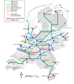
ファイル:Baanvaksnelheden.png

このプレビューのサイズ: 496 × 600 ピクセル。 その他の解像度: 198 × 240 ピクセル | 397 × 480 ピクセル | 635 × 768 ピクセル | 1,187 × 1,435 ピクセル。
元のファイル (1,187 × 1,435 ピクセル、ファイルサイズ: 351キロバイト、MIME タイプ: image/png)
ファイルの履歴
過去の版のファイルを表示するには、その版の日時をクリックしてください。
| 日付と時刻 | サムネイル | 寸法 | 利用者 | コメント | |
|---|---|---|---|---|---|
| 現在の版 | 2012年10月17日 (水) 10:44 |  | 1,187 × 1,435 (351キロバイト) | Classical geographer | Hanzelijn now completed (even though still without traffic). Changed colours slightly, notably making the HSL-Zuid red, and the slowest lines black. Amsterdam-Utrecht still 160 km/h; upgrade to 200 km/h now in doubt, as explained at http://www.sp.nl/ve... |
| 2010年8月5日 (木) 21:48 |  | 1,265 × 1,529 (352キロバイト) | AgentX~commonswiki | Reverted to version as of 20:40, 27 July 2009 | |
| 2010年8月5日 (木) 21:46 |  | 1,265 × 1,529 (317キロバイト) | AgentX~commonswiki | ||
| 2009年7月27日 (月) 20:40 |  | 1,265 × 1,529 (352キロバイト) | Classical geographer | Newly added links are non-electrified. Also changed background from blurry image to fresh new image. (Actually, File:Blank map of the Netherlands.svg.) I also discovered the line from Heerlen towards Aken is non-electrified, judging from [[:File:Sta | |
| 2009年7月27日 (月) 19:45 |  | 1,743 × 1,986 (899キロバイト) | Classical geographer | Several small fixed: * moved some stations to better locations * removed some small stations (without labels) that are not end-points or really important junctions; I'm considering whether to label them and, importantly, * added Betuweroute * added inte | |
| 2009年7月11日 (土) 08:20 |  | 1,394 × 1,588 (639キロバイト) | Classical geographer | Moved Enkhuizen onto land. Also adjusted Lelystad and (invisible) Meppel somehwat. | |
| 2009年4月8日 (水) 17:24 |  | 1,573 × 1,942 (1.08メガバイト) | T Houdijk | More changes; Zutphen-Hengelo is non-electrified | |
| 2009年2月20日 (金) 20:36 |  | 1,573 × 1,942 (1.19メガバイト) | Classical geographer | Another change: Leeuwarden-Groningen 140 km/h all the way, instead of only the double-track section. Also added scale and north arrow. | |
| 2008年3月15日 (土) 15:13 |  | 1,743 × 1,986 (352キロバイト) | T Houdijk | Fixed a few errors in this map. | |
| 2007年12月3日 (月) 16:15 |  | 1,743 × 1,986 (528キロバイト) | Classical geographer |
ファイルの使用状況
以下のページがこのファイルを使用しています:
グローバルなファイル使用状況
以下に挙げる他のウィキがこの画像を使っています:
- de.wiki.x.io での使用状況
- en.wiki.x.io での使用状況
- es.wiki.x.io での使用状況
- fr.wiki.x.io での使用状況
- hu.wiki.x.io での使用状況
- nl.wiki.x.io での使用状況
- sv.wiki.x.io での使用状況

